Source: David Sacks / Getty
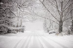
The region may be dealing with the coldest weather of the season so far — but it should brace for a major event later this week with several inches of snow, NBC4 meteorologists say.
It is too soon to say when exactly the snow will begin, but it will likely fall Friday evening and continue through Saturday, says meteorologist Veronica Johnson.
While the tracks of the storm and the amounts are shifting this early in the week, it looks like this will be a major storm, with a high probability of many areas seeing more than 12 inches of snow, Johnson says.
More concrete information about the snowfall amounts and affected areas will be released as the storm gets closer and more definitive judgments can be made, Johnson says.
Drivers should expect this storm to complicate their commutes, says meteorologist Matt Ritter. There is the possibility of high drifts east of I-95 as well as power outages.
“[The] storm still looks like it will significantly impact travel throughout the WTOP listening area and the Mid-Atlantic,” he says.
The National Weather Service says the winter storm threat is high for the region, with the threat of heavy snow, high winds and coastal flooding.
“We can say with confidence that a high impact winter storm will affect most, if not all of the area Friday through Saturday,” the weather service says.
The impending storm has brought back memories of Snowmageddon, the storm in 2010 that dumped more than two feet on some parts of the area. Forecasters are studying the computer models, wondering whether this week’s storm will be on the same level.
“It’s a small possibility at this time,” says Luis Rosa, a meteorologist with the National Weather Service. “We can’t completely rule it out.”
The snow comes after days of frigid temperatures in the D.C. area.
Wind gusts ranged from 20 to 30 mph Tuesday morning, helping to drive wind chills down to minus-6 degrees in Martinsburg, while in the District, the wind chills were a balmy one degree. Many schools in the area were delayed.
Those winds are supposed to lighten up on Wednesday, and highs will approach the freezing mark, with some flurries and perhaps a dusting Wednesday evening.
source: WTOP.com